Satellite observation
Land-cover condition, surface moisture indicators, disturbance and change detection.
WIDE COVERAGE / REPEATABLEMEASUREMENT / REPORTING / VERIFICATION
Each reported result must be connected to a location, time, instrument, method, quality check and documented calculation. The monitoring system is being designed around that requirement.
No single sensor can demonstrate the project's climate performance. Satellite data provides broad coverage, field instruments measure local conditions, and laboratory and flux measurements support the carbon calculations.
Land-cover condition, surface moisture indicators, disturbance and change detection.
WIDE COVERAGE / REPEATABLELiDAR or photogrammetry for microtopography, drainage and restoration design.
HIGH SPATIAL DETAILSpecies composition, cover and ecological condition as direct evidence and potential proxy.
FIELD-VERIFIEDContinuous or frequent water-table measurements across treatment and reference areas.
TIME SERIESDepth, bulk density, carbon content, stratigraphy and physical condition.
STOCK CHARACTERIZATIONCO₂ and CH₄ measurements used where required to quantify or validate net performance.
CLIMATE OUTCOMEThese drawings describe the proposed monitoring system. Final instrument models, station locations, sampling density, data products and methods remain subject to field design, methodology requirements and validation.
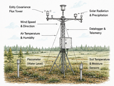
A proposed eddy-covariance station links atmospheric exchange with meteorology, soil conditions and piezometric water-level observations.
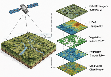
Repeated satellite observations and high-resolution terrain data provide the spatial frame within which field measurements are interpreted.
The proposed system will retain raw records, calibration status, quality flags, data transformations and calculation versions. A reported total should be reproducible from its original inputs.
Sampling frequency and density must reflect how conditions vary across the site and through the seasons. The goal is a defensible estimate whose limits are stated clearly.
Divide the landscape into meaningful condition classes; place treatment, control and reference observations deliberately.
Measure frequently enough to capture spring recharge, summer drawdown, storms and year-to-year variation.
Document calibration, maintenance, drift checks, outages and co-located instruments where risk warrants.
Carry measurement, sampling and model uncertainty through to reported results and conservative deductions.
Separate data collection, calculation approval and change authorization; retain reasons for every revision.
An approved validation/verification body reviews conformance and evidence before any registry issuance decision.
The project design must first be validated. Monitored results must then be independently verified, and the programme registry decides whether serialized units can be issued.
Boundary, rights, baseline, additionality, safeguards, methodology and monitoring plan.
Independent assessment of the design against programme and methodology rules.
Documented results for a defined period, including deviations, leakage and uncertainty.
Independent review of calculations, controls and supporting evidence.
Programme review and, if requirements are met, issuance of serialized units.
Separate tests for ICAO programme approval, scope, vintage and host authorization.