Orange follows peatland classes in Québec’s potential wetland inventory: bogs, fens, wooded peatlands and undifferentiated open peatlands. These are mapped potential habitats, not verified eligible project hectares.
Choose Explore restoration to move the water and vegetation layers. The mapped baseline remains a dated record of public source data.
HSP / DEVELOPMENT FRAME
11,000 ha
Preliminary planning area. Final boundary, tenure, eligible activity area, baseline and field condition remain subject to project development.
EARLY QUANTIFICATION
99,000
tCO₂e/year preliminary planning estimate. This is not a forecast of issuance, a verified result, or evidence of CORSIA eligibility.
PROJECT 01 / FLAGSHIP
The project at Havre-Saint-Pierre.
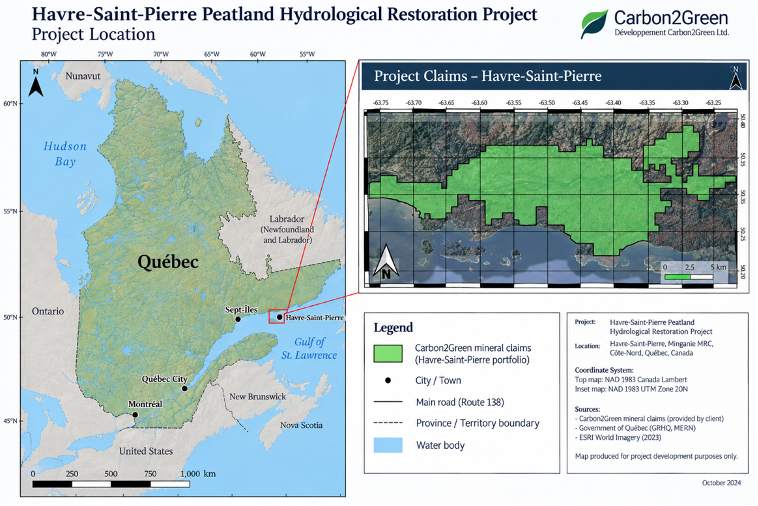
The combined map places the current claim area within Québec’s North Shore, with its coordinate grid, legend and scale retained.
Havre-Saint-Pierre, Québec · Project-development map, October 2024. Enlarge to inspect the labels and claim boundaries.
THE CLIMATE BEHIND THE LANDSCAPE
A cool climate, shaped by water.
Havre-Saint-Pierre sits on Québec’s North Shore. Published HSP-area climate records describe a cool setting with annual precipitation of roughly 900–1,000 mm. The station record cited in the Bouleau peatland study has positive monthly mean temperatures from May to October. Prijac et al., 2022
1.7°CMean annual air temperature
901 mmMean annual precipitation
487 mmAnnual potential evapotranspiration
1.85Precipitation ÷ potential evapotranspiration
HSP coastal study site, 50.256°N, 63.445°W. Climate variables: CRU gridded time series, 1991–2020, reported in Arsenault et al. (2023), Table 1. Ratio calculated as 901 ÷ 487. These are nearby-site data, not a climate extraction over the project boundary.
Why the IPCC pathway leads to “cool temperate.”
The steps below apply the IPCC default climate-region framework to that coastal HSP dataset. “Temperate” here is an accounting classification—not a claim that winters are mild.
01 / TROPICAL TEST
Annual mean above 18°C, with no more than seven frost days?
No. At 1.7°C, the temperature condition fails. Frost and tropical elevation tests do not change this route.
−0.7°C. Nearby inland conditions differ; the coastal result must not be extended indiscriminately across the region.
A landscape can have boreal vegetation while following a cool-temperate accounting pathway. The Bouleau study explicitly describes boreal forest alongside the positive HSP station temperature. Final project classification requires a documented assessment over the eligible boundary. It does not, by itself, establish acceptance under Verra VM0036 or confirm carbon-credit eligibility.
LIFE IN AND AROUND THE PEATLANDS
Meet some of the plants and wildlife of the region.
There are published flora and fauna records for nearby peatlands and the Mingan Archipelago. They help describe the wider landscape, but they are not an inventory of the Carbon2Green project parcels. Island geology and habitats also differ from the mainland.
Regional records—not confirmed project-site presence.A project-boundary inventory has not been verified for this page. Each entry below identifies where its supporting record comes from.
Selected published records. Not an exhaustive list or a species-at-risk assessment.
Group
Plant or animal
Short description
Recorded context / source
Flora
Sphagnum mosses
Peat-forming mosses that retain water and can slow organic-soil decomposition.
Sources: Parks Canada’s regional flora, wildlife and research pages, and the published Bouleau peatland study. These records do not demonstrate a biodiversity gain caused by the project.
THE DEVELOPMENT PATH
Development will proceed in clear stages.
01Rights
02Field baseline
03Design
04Validation
05Restoration
06Monitoring
07Verification
What Carbon2Green can say about the project will change as each stage is completed. Preliminary planning figures will remain separate from validated designs, monitored performance, verified outcomes and any units that may eventually be issued.