Science & MRV
Measured. Transparent. Verifiable.
Carbon2Green applies a dense, multi-layer Measurement, Reporting and Verification (MRV) system designed to quantify, document and independently verify peatland carbon performance for institutional and aviation buyers.
Project monitoring and verification will follow the applicable Verra/VCS methodology and project-specific monitoring plan. Final validation, verification and issuance remain subject to independent review and applicable program requirements.
Integrated evidence system
Three layers of evidence. One auditable carbon record.
Ground instrumentation, geospatial monitoring and peatland ecology are combined to reduce uncertainty and document how the project changes over time.
1. Field Measurement Equipment
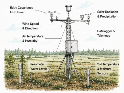
- Eddy Covariance systems measure continuous CO₂, CH₄ and H₂O fluxes.
- Piezometers monitor water-table depth across the project area.
- Soil temperature, moisture and meteorological sensors track key environmental drivers.
- Field data are recorded continuously and incorporated into the project MRV record.
2. Geospatial Monitoring
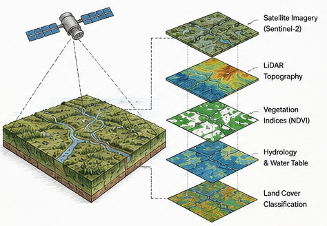
- Satellite imagery supports land-cover, vegetation and disturbance monitoring.
- LiDAR and high-resolution terrain models map microtopography and surface-flow pathways.
- Hydrological mapping links terrain conditions to water-table response.
- Multi-temporal analysis documents change across the project perimeter.
3. Understanding Peat
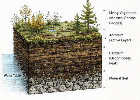
- Peatlands store carbon under waterlogged conditions that slow organic-matter decomposition.
- Lower water tables increase oxygen exposure and can accelerate peat oxidation.
- Hydrological restoration is designed to re-establish wetter conditions and reduce continued carbon loss.
- Peat depth, bulk density, carbon content and vegetation are characterized through field and laboratory work.
MRV architecture
Field data and remote sensing work together.
No single instrument determines project performance. The monitoring system combines complementary measurements so hydrology, greenhouse-gas fluxes, vegetation and peat conditions can be interpreted together.
Measure
Collect field, hydrological, ecological and geospatial observations.
Integrate
Combine data into a controlled project database and monitoring workflow.
Quantify
Apply the applicable methodology, baseline and project parameters.
Verify
Provide auditable evidence for independent validation and verification.
Integrity at every step
Designed for institutional scrutiny.
The purpose of the MRV system is straightforward: create a transparent evidence chain that allows validators, verifiers, buyers and investors to understand how project performance is measured and how carbon claims are supported.